HOME    Search    Email    Use Photos    Sitemap    Links     JAMES BAY ROAD WEBSITE (travel info)    Rupert Reverence website
 Virtual Tour:  at James Bay Roadat North Road     Movies    Diversion    Winter    Canoeing    Waskaganish    Art

Virtual Tour
as seen from the James Bay Road


Thanks for stopping in to have a look at the Rupert River. In less than three years (2007) this magnificent wild river will be diverted northward and the spectacular rapids featured here will be no more, thanks to Hydro Quebec!!

The James Bay Road is where most people experience the raw power of the Rupert River. This Road crosses the Rupert just downstream from a massive set of spectacular rapids. There's a rest area with a viewing platform just off the road. The bridge itself also provides an excellent place from which to view the rapids.

The rapids just east (upstream) of the bridge are absolutely awesome. Commonly known as the Oatmeal Rapids, they're called Kaumwakweuch Rapids on topo maps. If you're traveling up here, then definitely stop and have a look. They are, by far, the most awe-inspiring rapids I have ever seen. If you want to get up close and personal, there is also a short trail that runs along the north shore of the Rupert River, which brings you much closer to the rapids.


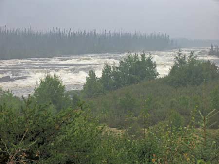
But, if you can't get up to the Rupert River, let this website bring the Rupert to you! There are lots of photographs here, plus movies of these spectacular rapids. Some of these were taken quite close to the rapids, in order to convey the raw power and strength of this river. This is somewhat of a virtual tour of the Rupert River at the James Bay Road crossing.

Unfortunately, every time I have visited the Rupert River, it has been overcast! Hopefully next summer I will get back up there when it is sunny to properly capture this spectacle.

I am presenting a rather large number of photographs and movies here in order to preserve the memory of these rapids.

BEGIN HERE with the South Side of the river (click here)
or go directly to the North Side
or go directly to the view from one mile upriver of the rapids

Or go directly to the pages with MOVIES:
South side    North side    One Mile Upriver


Here is a 1:250,000 topo map of the area where the James Bay Road crosses the Rupert River


For more information about this area, visit the James Bay Road website

 Rupert River

The material on this page is copyright © by the original author/artist/photographer
This website is created, maintained & copyright © by Walter Muma
Please respect this copyright and ask permission before using or saving any of the content
of this page for any purpose

-- These websites may also interest you --

Ontario Wildflowers   Ontario Trees & Shrubs   Ontario Ferns   Ontario Grasses   Ontario Insects
Mumart   World of Mosses   Wild Ontario   Trans-Labrador Hwy   James Bay Road   Rupert River   Moped Trip
Wildwood Survival   Wildwood Tracking   Leatherwood Trail   Tracker Trail   Earth Caretaker   Wildwood Canada

Thank you for visiting!